Saudi Arabia Map Outline black outline icon

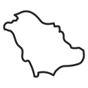

Outline map silhouette of Saudi Arabia showing its national borders
Related tags
About the Saudi Arabia Map Outline black outline icon
The borders of the Kingdom of Saudi Arabia are traced as a single closed shape, with the notched northern frontier, the long western Red Sea coast and the eastern Gulf edge all visible. It stands for the country, the region and Middle Eastern geography generally. Useful in travel booking sites, shipping and logistics coverage maps, school geography material, market-report slides, and country pickers.
The outline keeps a uniform stroke and rounded corners, simplifying small inlets while preserving the recognizable wedge proportion of the peninsula. It pairs with other country map shapes and with flag icons from the library. Because the form is wide and irregular, align it optically rather than to its bounding box when placed in a grid.
This is the black outline version of the saudi arabia map outline icon: even, monoline strokes that stay crisp at small sizes and suit clean, minimal interfaces, wireframes and light backgrounds.
Download it free as a scalable SVG vector or transparent-background PNG in seven sizes (16 to 512px), copy the SVG code straight into your project, or open it in the free online editor to change colors, apply gold, silver, neon and gradient styles, animate it, or convert it to EPS, PDF and DXF.
Free for personal and commercial use with attribution.