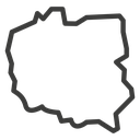
Poland Country Map black outline icon



Outline map of Poland showing national borders and Baltic coastline
Related tags
About the Poland Country Map black outline icon
The national territory of Poland drawn as a single closed contour: a flat Baltic coast along the top, the Oder line down the west, the jagged Carpathian and Sudeten edge across the south and the long eastern border. Use it in travel and booking sites, shipping and delivery coverage maps, language and currency selectors, geography lessons and European market reports.
The silhouette stays roughly square in proportion, so it drops cleanly into a grid of country map icons without extra padding. Pair it with Germany, Czech Republic and Ukraine maps for a regional set. Below 32px the southern border notches smooth out, so size accordingly.
This is the black outline version of the poland country map icon: even, monoline strokes that stay crisp at small sizes and suit clean, minimal interfaces, wireframes and light backgrounds.
It downloads free as an SVG vector or transparent PNG in seven sizes, and the free online editor lets you recolor it, apply gold, silver, neon and gradient styles, add animation, or convert it to EPS, PDF and DXF.
Free for personal and commercial use with attribution.