Ecuador Map Outline black outline icon


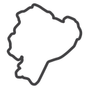
Outline map of Ecuador showing its national border and Pacific coastline
Related tags
About the Ecuador Map Outline black outline icon
This is the national border of Ecuador traced as one continuous line, with the jagged Pacific coastline on the west and the Amazon frontier tapering to the southeast. It stands for the country itself, its territory, and locations within it. Useful for travel and tourism sites, shipping and coverage maps, country selectors, geography teaching material, and Latin America market reports.
The silhouette is simplified but keeps the recognizable notch on the northwest coast and the pointed southern tip, so it stays identifiable without internal detail. It pairs with other South American country maps and with flag icons in the same collection. Place it on a plain background and avoid tiny sizes, where the coastal detail flattens out.
This is the black outline version of the ecuador map outline icon: even, monoline strokes that stay crisp at small sizes and suit clean, minimal interfaces, wireframes and light backgrounds.
Download it free as a scalable SVG vector or transparent-background PNG in seven sizes (16 to 512px), copy the SVG code straight into your project, or open it in the free online editor to change colors, apply gold, silver, neon and gradient styles, animate it, or convert it to EPS, PDF and DXF.
Free for personal and commercial use with attribution.